|
|||||||||||

Deutsch
English
Transport Atlas of Switzerland

Usage
Any use of the maps for commercial purposes requires permission of the IVT.
Part of the results of COST 340, a recent internationally funded project, is a series of images and maps representing the development of transport in Switzerland since 1950.
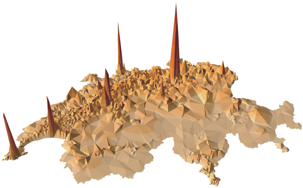
It can be argued that the central objective of Swiss transport policy in the last 150 years has been to improve accessibility, which links investment, the change in land use and economic growth with the systematic increase in market sizes of companies and activity spaces of people.
The level of accessibility is the result of the log sum term of a simple destination choice model (see Williams, 1974), which is based on the resident population and the travel times between the municipalities. These are calculated seperately for private and public transport. The values account for the effects caused by the population in the areas surrounding Switzerland (see Fröhlich and Axhausen, 2004).
The size of the country seems to have shrunk, if improved speeds and decreased travel times are taken into consideration. This changing shape has been traced by constructing time-scaled maps, where distances have to be read as travel time and not as distances (see Carosio, Dolci and Scherer, 2005).
| Accessibility and time-scaled Maps 1950-2000 | ||
|
Year |
Public Transport |
Road Travel |
|
1950 |
Download (PDF 16.1MB) |
Download (PDF 20.6MB) |
| 1960 |
Download (PDF 16.7MB) |
Download (PDF 17.1MB) |
| 1970 |
Download (PDF 17.0MB) |
Download (PDF 17.4MB) |
| 1980 |
Download (PDF 16.8MB) |
Download (PDF 17.7MB) |
| 1990 |
Download (PDF 17.0MB) |
Download (PDF 18.0MB) |
| 2000 |
Download (PDF 16.8MB) |
Download (PDF 18.2MB) |
| Overviews | ||
|
Poster of all maps: Accessibility and time scaled maps of Switzerland since 1950 |
Download (PDF 9.0MB) |
|
| Overview maps for road travel and public transport 1950-2000 |
Download (PDF 24.0MB) |
|
|
Brochure time-scaled maps |
Download (PDF 19.0MB) |
|
| Population density 1950-2000 | ||
| Overview 1950-2000 (with captions) |
Download (PDF 26.0MB) |
|
| 1950 |
Download (PDF 1.5MB) |
|
| 1960 |
Download (PDF 1.6MB) |
|
|
1970 |
Download (PDF 1.6MB) |
|
| 1980 |
Download (PDF 1.6MB) |
|
| 1990 |
Download (PDF 1.6MB) |
|
| 2000 |
Download (PDF 1.6MB) |
|
| Commuting distances | ||
| Development 1970-2000 |
Download (PDF 0.8MB) |
|
Wichtiger Hinweis:
Diese Website wird in älteren Versionen von Netscape ohne
graphische Elemente dargestellt. Die Funktionalität der
Website ist aber trotzdem gewährleistet. Wenn Sie diese
Website regelmässig benutzen, empfehlen wir Ihnen, auf
Ihrem Computer einen aktuellen Browser zu installieren. Weitere
Informationen finden Sie auf
folgender
Seite.
Important Note:
The content in this site is accessible to any browser or
Internet device, however, some graphics will display correctly
only in the newer versions of Netscape. To get the most out of
our site we suggest you upgrade to a newer browser.
More
information

!!! Dieses Dokument stammt aus dem ETH Web-Archiv und wird nicht mehr gepflegt !!!
!!! This document is stored in the ETH Web archive and is no longer maintained !!!
!!! This document is stored in the ETH Web archive and is no longer maintained !!!